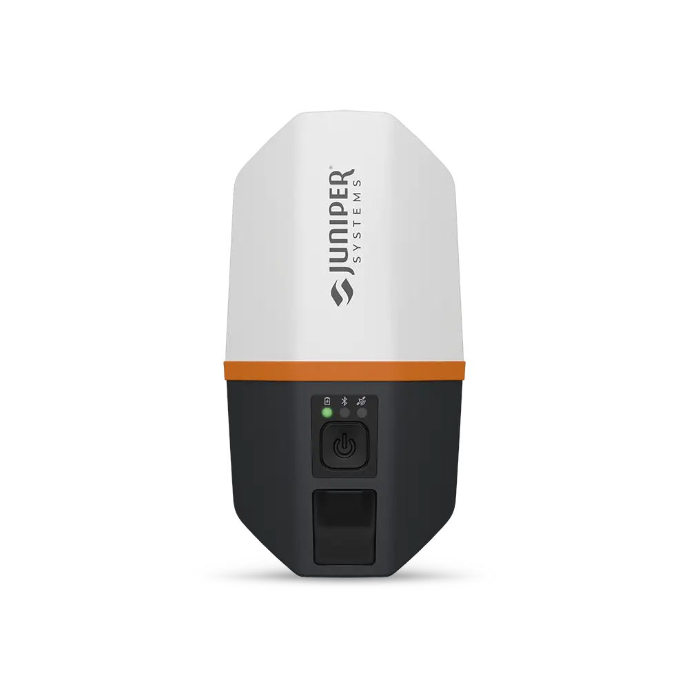
Juniper Systems Spire
Lightweight Multi-Frequency RTK GNSS Receiver
Enhance your field data collection with the Juniper Systems Spire, available at Eastcom Associates. The Spire is Juniper's lightest multi-frequency GNSS receiver, built for utility, municipal, and GIS professionals who need real-time RTK accuracy down to roughly 1.5 to 2 centimeters, without the weight, cost, or complexity of a traditional survey rig. It pairs over Bluetooth with the devices you already use and streams precise position data straight into your mapping apps. Simple enough for any crew, accurate enough for production work.
Key Features and Benefits
- Juniper's Lightest GNSS Receiver: At roughly 320 grams (under 12 oz), the Spire mounts on a pole or rides in a pack all day without the fatigue of a heavier receiver.
- Multi-Frequency RTK Accuracy: L1/L2/L5 tracking across all six satellite constellations delivers roughly 1.5 to 2 centimeters with Network RTK and faster, more reliable position fixes.
- Corrections Without a Base Station: SBAS provides sub-70 cm accuracy out of the box; Network RTK corrections stream over the internet through your paired device, no base station or radio to manage.
- Bring-Your-Own-Device Compatibility: Connects over Bluetooth to Windows, Android, and iOS, and streams directly into ArcGIS Field Maps, Survey123, SW Maps, and other mobile GIS apps.
- All-Day Battery Life: Up to 20 hours of continuous use on a single charge keeps crews collecting through the longest field days.
- One-Button, Cable-Free Operation: An integrated helical antenna and single-button design mean fast deployment with no cables and nothing extra to assemble.
- Rugged Field Build: IP68 sealing against dust and water, MIL-STD-810H shock and vibration testing, and a -20 °C to +60 °C operating range stand up to year-round field conditions.
- Backed by Eastcom: Designed and assembled in the USA and supported with free on-site training, lifetime technical support, and fast service from our factory-trained New Jersey repair center.
Technical Specifications
- Accuracy: Better than 70 cm with SBAS; approximately 1.5–2 cm with Network RTK
- Frequencies: Multi-frequency L1 / L2 / L5
- Constellations: GPS, GLONASS, Galileo, BeiDou, QZSS, NavIC
- Corrections: SBAS, Network RTK (Juniper RTK), future correction services
- Update rate: Up to 20 Hz
- Antenna: Integrated helical; no external antenna required
- Connectivity: Bluetooth to Windows 10/11, Android, and iOS (iPad / iPhone)
- Battery life: Up to 20 hours on a single charge
- Weight: Approximately 320 g (under 12 oz)
- Environmental: IP68 rated; tested to MIL-STD-810H; -20 °C to +60 °C
- Software: Juniper Connect
- Origin: Designed and assembled in the USA (Logan, Utah)
Spire or Geode: Which Juniper GNSS Receiver Is Right for You?
Eastcom carries both of Juniper's GNSS receivers, and many customers ask which one fits their work. The Spire is the lighter, longer-running choice with multi-frequency RTK built in and a simple correction path. The Geode GNS3 is a scalable platform with the broadest menu of corrections, including subscription-free Galileo High Accuracy Service plus wired NMEA and serial output for legacy integrations. Use the quick comparison below, or call us and we will help you choose.
Configuration & What's in the Box
The Spire is stocked as a complete, field-ready kit. Configuration SP1-CFG-1457, the Spire GNSS Receiver, US/NA/EU with Charger, includes everything needed to charge, connect, and collect:
- Spire GNSS Receiver: the multi-frequency RTK unit detailed above.
- Universal AC Charger: supports US, North America, and Japan.
- International Plug Adapters: EU and UK adapters included.
- USB-C Cable: for both charging and data transfer.
Call 908-722-7774 for current pricing and configuration options.
Why Choose the Spire from Juniper Systems?
The Juniper Systems Spire is the ideal choice for professionals who want centimeter-level positioning in the most portable receiver Juniper makes. Its one-button operation, multi-platform compatibility, and rugged all-day build make it an easy addition to any utility, municipal, or GIS workflow. And when you buy the Spire from Eastcom Associates, you get more than hardware: free on-site training, lifetime technical support, and fast repair service from our factory-trained technicians in Branchburg, New Jersey. Elevate your data collection with pinpoint precision and rugged reliability.
Built for the Industries We Serve
From mark-out response to long-term asset management, the Spire supports the professionals Eastcom partners with across the Northeast and Mid-Atlantic:
- Municipal & Public Works: Map water, sewer, and stormwater assets directly into GIS.
- Power & Gas Utilities: Record distribution infrastructure for damage-prevention and asset programs.
- Telecom: Georeference buried lines and new installations after locating.
- Locating & GPR Contractors: Add precise positioning to deliver client-ready maps.
- Survey & SUE Support: Capture accurate utility positions for pre-design and as-built work.
Frequently Asked Questions
Is the Spire a replacement for the Geode, or a different tool?
Neither receiver replaces the other; they suit different priorities. The Spire is the lightest, longest-running option with multi-frequency RTK built in and a single, simple correction path. The Geode is a scalable platform you can grow over time, with a wider correction menu and wired NMEA/serial output. Many crews choose the Spire for fast, all-day RTK collection and the Geode when they need that flexibility; Eastcom can help you decide based on how you work.
What correction service does the Spire use, and is a subscription required?
For centimeter accuracy, the Spire uses Network RTK corrections delivered over the internet through your paired device. Juniper RTK, built on a nationwide reference-station network, is the turnkey service and runs as a subscription. For SBAS accuracy (better than 70 cm), no subscription or connection is required. Ask Eastcom about current Juniper RTK options and coverage in your area.
Can I use the Spire with my own RTK network or NTRIP credentials?
The Spire is designed to work with Network RTK corrections, with Juniper RTK as the first-party option. If your organization already has access to a specific RTK network or NTRIP caster, contact Eastcom before purchase so we can confirm compatibility for your setup.
How does multi-frequency (L1/L2/L5) tracking help in the field?
Receiving multiple signals from each satellite lets the Spire converge on a fixed RTK solution faster and reject multipath error more effectively. In practice, that means quicker time-to-fix and steadier accuracy under tree canopy, near buildings, and in the urban corridors common across the Northeast and Mid-Atlantic conditions, where single-frequency receivers struggle.
Is the Spire accurate enough for SUE and as-built deliverables?
Configured for Network RTK, the Spire delivers centimeter-level horizontal positioning suitable for high-precision asset capture and as-built records, including subsurface utility engineering data collection. If your project must meet a specific accuracy standard or tolerance, confirm the requirement first and configure corrections accordingly. Our team can advise.
Does Eastcom offer demos, training, and financing for the Spire?
Yes. Eastcom provides free, no-obligation on-site demonstrations and hands-on application training, lifetime technical support, and financing options. Repairs and service are handled in-house by our factory-trained technicians at our Branchburg, New Jersey headquarters.
Request a Quote Today
Upgrade your field equipment with the Juniper Spire. Contact us for pricing details.
Call For Pricing 908-722-7774
Hathorn Wi-Fi Reel Insights: Enhance Your Inspections
Wireless Functionality for Efficient Pipe and Sewer Inspections
The Hathorn Wi-Fi Sewer Camera Reel is a powerful yet simple-to-use pipe inspection camera that connects wirelessly to your Android or iOS device. By eliminating the need for a dedicated monitor, this system reduces overall costs while providing real-time access to inspection footage. Users can view, record, capture images, and take notes directly on their phone or tablet, streamlining the inspection process.
This Wi-Fi pipe inspection camera is available in lengths of 100, 200, or 400 feet, making it adaptable for various applications, including sewer inspections and drain tracing. Its integrated 512 Hz sonde enables precise camera head location when using a utility locator, ensuring accuracy in identifying problem areas. Designed for portability and durability, the Hathorn Wi-Fi Reel is an excellent choice for professionals seeking an affordable wireless sewer camera.
At Eastcom, we offer comprehensive training to help you get the most out of your Hathorn Wi-Fi Reel.
Get Your Quote:
Looking to upgrade your inspection tools? Fill out the form below to request a price quote for the Hathorn Wi-Fi Reel and see how it can improve your operations today!
Jameson Duct Hunter Insights: Discover Its Full Potential
A Traceable Duct Rodder Designed for Reliable Underground Utility Mapping
The Jameson Duct Hunter is a dependable traceable duct rodder that transforms untraceable lines into detectable paths for your underground pipe locator. By applying a transmitter signal to the rod, you can easily locate and map underground utilities, even in complex environments.
This detectable fiberglass rodder is available in multiple sizes, lengths, and thicknesses, allowing it to navigate pipes with tight bends or challenging angles. Certain models are equipped with fittings and stuffing boxes, making them suitable for live gas or water line applications. Whether you're tackling routine tasks or specialized projects, the Duct Hunter delivers consistent results.
To maximize effectiveness, always push as much of the traceable rod into the pipe as possible. This ensures the transmitter signal is carried through the rod, making it easy to detect with a non-invasive utility locator.
Get Your Quote:
Looking for an efficient way to locate underground utilities? Fill out the form below to request a quote for the Jameson Duct Hunter and discover how this portable underground pipe locator can improve your operations today!
SubSurface LC-5000 Insights: Efficiently Pinpoint Leaks
Accurate Detection for Water Leak Prevention
The SubSurface LC-5000 Digital Quatro Leak Correlator is an advanced solution for detecting and locating water leaks with unmatched precision. Building on the legacy of the LC2500, this system combines real-time correlation capabilities with advanced logging features, making it an essential tool for comprehensive leak detection programs. Its logging mode enables overnight surveys to monitor water systems continuously, identifying leaks before they escalate into costly issues.
Available in two options—a two-sensor system or a four-sensor system—the LC5000 employs high-sensitivity preamplifiers to detect pipe vibrations and calculate leak locations. Users input key details such as pipe material, diameter, and distance, enabling the system to deliver precise results. The four-sensor model doubles as a relay system, allowing reliable communication across extended pipe runs of up to 1,900 feet, ideal for large-scale applications.
Key Features of the SubSurface LC-5000:
- Real-Time Correlation: Detects leaks in real time for immediate action.
- Advanced Logging Mode: Perform overnight surveys to continuously monitor pressurized water systems.
- Four-Sensor Relay Capability: Extend detection range up to 1,900 feet using relay communication.
- Digital Signal Processing: Analyze leak sounds with precision, even in metal or plastic pipes.
- Flexible System Options: Choose between two-sensor and four-sensor models to match application needs.
Water loss from undetected leaks can result in significant financial losses for municipalities and utility providers. The LC5000 digital leak correlator identifies leaks efficiently, reducing water waste and preserving infrastructure integrity.
Get Your Quote:
Prevent unnecessary water loss and costly repairs. Fill out the form below to request a quote for the SubSurface LC-5000 Digital Quatro Leak Correlator and enhance your leak detection program today!
UTTO vLocate Mapper Insights: Map with Precision
Portable High-Precision Utility Mapping and Locating System
The UTTO Utility Mapping and Locating System offers a simple yet powerful solution for accurate utility mapping. Utilizing an RTK network, this system provides sub-foot precision, achieving accuracy as fine as 10 cm. Its walk-back feature allows users to relocate and map utilities efficiently, ensuring precise data collection.
Designed for modern utility professionals, the UTTO system is compatible with iOS and Android devices, allowing for seamless Bluetooth pairing with smartphones or tablets. This GPS utility mapping system streamlines data collection with an intuitive interface—just a few clicks, and you’re ready to map utility lines. Real-time data transfer to platforms like ArcGIS Field Maps ensures immediate integration, while compatibility with other GIS platforms such as Uinta and Pointman allows for flexible data management.
The portable utility locating device simplifies workflows by enabling locators to identify utility lines with traditional equipment and then quickly map the lines using the UTTO mapper. The system is ideal for applications requiring high-precision utility mapping tools and supports a variety of export file formats for easy sharing and analysis.
Key Features of the UTTO vLocate Mapper:
- Sub-Centimeter Accuracy: Provides precision down to 10 cm for detailed mapping.
- Real-Time GIS Integration: Supports platforms like ArcGIS and Uinta.
- Easy-to-Use Interface: Simple setup and operation for efficient utility line mapping.
- Portable Design: Enables seamless field use with iOS and Android compatibility.
Get Your Quote:
Ready to optimize your utility mapping process? Fill out the form below to request a quote or schedule a demonstration of the UTTO Utility Mapping and Locating System today!
CAT4+ Insights: Precision Cable and Utility Detection
A Comprehensive Tool for Safety and Efficient Utility Locating
The CAT4+ Cable Avoidance Tool is designed to provide contractors and utility professionals with a reliable solution for underground detection. This versatile tool is ideal for conducting quick safety sweeps in excavation areas, especially where unmarked utilities may pose a risk. It’s an essential component of any utility detection equipment set, helping prevent costly damages.
With multiple detection modes, the CAT4+ adapts to a variety of scenarios:
- Power Mode: Detects live current-carrying lines.
- Radio Mode: Identifies ambient RF noise emitted by buried conductors.
- Avoidance Mode: Combines power and radio modes, allowing a comprehensive sweep in one pass, saving time and improving efficiency.
For enhanced utility location, pair the CAT4+ with the Jenny transmitter. This portable cable detection device emits signals at 33 kHz and 131 kHz simultaneously, enabling basic locating functions. The CAT4+ can trace these signals along underground utilities, ensuring precise detection of buried lines like phone cables, site lighting, or even dog fences that may not carry current.
Key Benefits of the CAT4+:
- Multi-Mode Detection: Adaptable modes for power, radio, and combined detection.
- Enhanced Safety: Prevents damage to private and unmarked utilities.
- Seamless Transmitter Integration: Compatible with the Jenny transmitter for added locating capabilities.
- Durable and Reliable: Operates with two D-cell batteries and includes a three-year warranty.
- Professional Support: Backed by Eastcom’s training and support services.
The CAT4+ cable locator is a dependable solution for professionals needing both underground utility detection and basic locating capabilities. Its precision and ease of use make it the go-to choice for contractors who demand reliable results.
Get Your Quote:
Protect your projects with the CAT4+ Cable Avoidance Tool. Fill out the form below to request a quote and learn how this versatile tool can enhance your utility detection program!
Magnetic Locator Insights: Detection Tools for Professionals
Unmatched Accuracy for Locating Magnetic Metals Underground
The Schonstedt Maggie Magnetic Locator is a versatile and reliable tool designed for detecting buried metallic objects like valve boxes, manholes, and other underground utilities. It combines the precision and sensitivity of the GA-52 with the single-handed, ergonomic design of the GA-92, offering a powerful magnetic detection tool that’s easy to use in the field.
With advanced sensitivity controls and a polarity indicator, the Maggie Magnetic Locator simplifies locating tasks in complex environments. Whether near fences, vehicles, or other metallic interferences, the polarity shift ensures you can distinguish between objects and accurately pinpoint your target. The portable magnetic locator is lightweight and ideal for professionals needing a balance of precision and convenience.
Engineered for underground utility detection equipment, the Maggie stands out as a professional-grade tool. Its ability to provide high sensitivity while maintaining ease of use makes it suitable for contractors, surveyors, and utility professionals. The Maggie Magnetic Locator delivers reliable results, ensuring safety and efficiency on every project.
Key Features of the Maggie Magnetic Locator:
- Accurate Metal Detection: Designed for valve boxes, manholes, and buried objects.
- Advanced Sensitivity Controls: Adjustable settings for precise detection in challenging environments.
- Portable Design: Lightweight and ergonomic for single-handed operation.
- Professional-Grade Performance: Ideal for contractors and utility professionals.
Get Your Quote:
Looking for a reliable magnetic locator tool? Fill out the form below to request a quote for the Schonstedt Maggie Magnetic Locator and discover why it’s trusted by professionals for magnetic metal detection in underground utility projects!
Rust-Oleum Marking Paint Insights:
High-Quality, Efficient Marking Solutions
Rust-Oleum Marking Paint is an industry leader for utility detection and construction projects, offering both solvent-based and chalk-based varieties. Its innovative design delivers 40% more coverage per can, maximizing efficiency and reducing waste. The newly redesigned nozzle minimizes breakage, ensuring consistent application and fewer unusable cans.
At Eastcom, we provide some of the most competitive bulk pricing in the industry. Whether you’re marking utilities or construction zones, Rust-Oleum’s inverted utility marking paint offers durability and reliability for professional use.
Get Your Quote:
Contact us today for a price quote and make Eastcom your trusted supplier for Rust-Oleum Marking Paint!
Utility AirSpade 4000: Precision Excavation
Safe, Efficient, and Non-Destructive Utility Digging
The AirSpade 4000 by GuardAir is a high-performance air excavation tool designed to safely expose underground utilities. Using high-velocity air at Mach 2, it pulverizes dirt and soil without damaging buried lines, making it the perfect choice for non-destructive digging in construction and utility projects.
Key Features and Benefits:
- High-Velocity Air: Operates at Mach 2 to efficiently excavate soil without damaging utilities.
- Electrical Safety: Fiberglass barrel rated for 300 kV ensures user protection near energized lines.
- Durable Construction: Built for long-term use with a robust fiberglass barrel and dead man safety stick.
- Air Vacuum Compatibility: Pair with an air vacuum for a complete excavation solution.
- Optimal Performance: Requires a minimum compressor rating of 90 CFM, with 185 CFM recommended for best results.
The Utility AirSpade 4000 is ideal for applications requiring safe, precise, and non-invasive excavation. It eliminates the risks associated with traditional digging methods, reducing costly utility hits and ensuring efficient project completion.
Get Your Quote:
Enhance the safety and efficiency of your excavation projects. Fill out the form below to request a quote for the Utility AirSpade 4000 and discover why it’s trusted by professionals across the industry!
Utility AirSpade 4000 Kit: Complete Excavation Solution
All-in-One Kit for Safe and Efficient Utility Digging
The Utility AirSpade 4000 Kit offers everything you need for non-destructive digging in one convenient package. Designed for safe, precise excavation, this comprehensive kit includes the AirSpade 4000 and all essential accessories, making it ideal for exposing underground utilities without damage.
What’s Included in the AirSpade 4000 Kit:
- Utility AirSpade 4000 Tool: Delivers high-velocity air at Mach 2 for efficient soil excavation.
- Safety Guard: Protects operators during use in demanding environments.
- Adjustable Nozzle: Allows control over air output for varied soil conditions.
- Hose Assembly: Ensures a secure connection to your compressor for uninterrupted performance.
- Carrying Case: Durable and portable, ideal for transportation and storage of your equipment.
The AirSpade 4000 Kit is designed to handle the most demanding excavation tasks with precision and safety. Its fiberglass barrel, rated for 300 kV, ensures protection when working near energized utilities, while the adjustable nozzle provides flexibility to tackle different soil conditions. Pairing the kit with an air vacuum enhances debris removal, making your cleanup easy. Built for reliability, the kit works seamlessly with compressors of 90 CFM or greater, and for optimal performance, a 185 CFM compressor is recommended. With a focus on durability and ease of use, the AirSpade 4000 Kit is a trusted solution for contractors and utility professionals.
Get Your Quote:
Equip yourself with the ultimate excavation kit. Fill out the form below to request a quote for the Utility AirSpade 4000 Kit and experience safe, reliable, and efficient digging on every project!
Radiodetection RD7200 Insights: Locate with Confidence
High-Performance Utility Locator for Accurate Line Tracing and Fault Detection
Accurate utility locating requires more than just signal detection; it demands a tool capable of precise signal differentiation and line tracing. The RD7200 Precision Locator excels in isolating strong signals from weaker ones, enabling professionals to confidently identify their target lines. For example, when comparing two signals—one measuring 20 milliamps and another at 2 milliamps—the RD7200 ensures the stronger signal is correctly identified as the utility line. This advanced level of precision supports thorough tracing to known endpoints, aligning with industry best practices for utility locating.
The RD7200 locator supports both 5-watt and 10-watt transmitters, enabling users to adjust power based on the application. The 10-watt transmitter is ideal for long-distance tracing on resistive conductors, such as older cast iron pipes with multiple couplings. This additional power ensures that the RD7200 can handle even the most challenging utility locating tasks.
Key Features of the Radiodetection RD7200:
- Multifunction and Multifrequency Capability
- Locates sondes at 512 Hz, 8 kHz, and 33 kHz for use with inspection and pipe cameras.
- Compatible with a wide range of utility applications, including sewer inspections and cable tracing.
- Fault-Finding Precision
- Supports an optional A-frame accessory for detecting cable faults to ground.
- Applies a specialized signal with the transmitter to ensure accurate fault detection.
- Adjustable Power Options
- Choose between 5-watt and 10-watt transmitters to match the application.
- The 10-watt transmitter delivers greater power for long-distance tracing on resistive conductors like cast iron pipes.
- Durable and Low-Maintenance Design
- Backed by a three-year warranty with no required calibration schedule.
- Built to withstand harsh field conditions, ensuring long-term reliability.
The Radiodetection RD7200 offers industry-leading performance at a competitive price. Whether you're looking to purchase for immediate use or seeking financing options, the RD7200 provides exceptional value for utility professionals.
Get Your Quote:
For more details on the Radiodetection RD7200 price or to request a personalized quote, fill out the form below. Discover how this advanced utility locator can enhance your operations and improve locating accuracy today!
Make Your Mark With Eastcom
Eastcom Associates, Inc. has been a distributor of utility products since our inception in 1972. We currently stock a complete line of products dedicated to utility location, leak detection, fault location, and pipeline inspection.